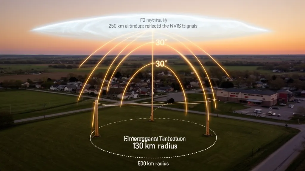
Why NVIS Eliminates the Problem That Ruins HF for EmComm
NVIS — Near Vertical Incidence Skywave — solves the most fundamental problem with conventional HF propagation for emergency communications and regional nets: the skip zone. Conventional HF propagation skips over everything within 300–2,000 km of the transmitter on frequencies above 10 MHz. A regional emergency net trying to cover a 200 km radius has the opposite problem: the distances they need to cover fall squarely in the skip zone of every band that carries reliable DX. NVIS eliminates the skip zone entirely, covering 0–600 km simultaneously from a simple wire antenna. This is why it is the backbone of military HF communications and ARES/RACES emergency radio.
Pro Tip: For EmComm planning, check the DXRadar solar weather page for current SFI — it directly correlates with foF2. If SFI is above 90, 40m NVIS will be reliable for most of the day. If SFI drops below 80, prepare to shift to 80m NVIS earlier. The best-bands-now page shows which bands currently have active propagation in your region.
The Physics of NVIS
Standard HF DX propagation sends energy at low angles (typically 5–20° above the horizon). These shallow-angle signals strike the ionosphere obliquely, reflecting back at a shallow angle and arriving 1,000–10,000 km away. The geometry creates an unavoidable skip zone around the transmitter.
NVIS inverts this geometry. Signals are sent at near-vertical angles (0–30°, ideally less than 15°). A vertically directed signal reaches the F2 layer directly overhead and reflects back nearly vertically, landing within a few hundred km of the transmitter. The signal covers a circle with radius roughly 0–600 km — and because there is no shallow-angle skip, the coverage extends continuously from the transmitter outward to that radius.
The foF2 Constraint
NVIS only works if the operating frequency is below foF2 at the local F2 layer overhead. Recall that foF2 is the maximum frequency for vertical incidence reflection. Above foF2, vertical signals pass through the ionosphere without reflection. Below foF2, they reflect.
This is the critical constraint:
Operating frequency < foF2 = NVIS works Operating frequency > foF2 = NVIS fails (signals escape into space)
When monitoring NVIS propagation, you are essentially monitoring whether local foF2 has dropped below your operating frequency. The DXRadar solar weather page shows live SFI, which correlates with foF2.
Path Length and Coverage Radius
At vertical incidence, the signal returns to the transmitter location. At slight off-vertical angles, it lands some distance away. The coverage radius depends on geometry and F2 layer height:
| Elevation Angle | Coverage Radius (F2 at 300 km) |
|---|---|
| 90° (vertical) | 0 km — signal returns to transmitter |
| 75° | ~80 km |
| 60° | ~170 km |
| 45° | ~300 km |
| 30° | ~520 km |
| 20° | ~830 km (transitional to skip) |
Practical NVIS coverage for a horizontal dipole at 0.1–0.2λ height spans roughly 0–500 km, with the strongest coverage at 150–400 km. Ground-wave fills in the near-field zone (0–50 km). Beyond 500–600 km, the geometry transitions to skip propagation, and a gap appears depending on the MUF.
Band Selection for NVIS
40m (7.0–7.3 MHz) — The Primary Daytime NVIS Band
40m is the workhorse NVIS band for daytime operations. foF2 at mid-latitudes typically ranges from 5–12 MHz depending on SFI and time of day. When foF2 exceeds 7.5 MHz, 40m NVIS is well supported with a comfortable margin. At SFI 100 and midday, foF2 is commonly 8–10 MHz — 40m NVIS is solid for most of the day from mid-morning to late afternoon.
At night, foF2 drops. If foF2 falls below 7 MHz, 40m NVIS fails. This typically happens after 21:00–23:00 local solar time at mid-latitudes during low-to-moderate solar flux periods. Watch for foF2 data from the nearest GIRO ionosonde to know your local threshold.
D-layer absorption is present on 40m during daylight hours, which reduces signal strength on NVIS paths compared to nighttime. The D-layer does not block 40m NVIS entirely under normal conditions — signals still complete NVIS paths — but signal-to-noise ratios are typically 6–15 dB worse at midday than at dusk. This is not a problem for regular EmComm or POTA, but it means power and antenna quality matter more in daytime operations.
80m (3.5–4.0 MHz) — The Nighttime NVIS Band
After sunset, 80m is the preferred NVIS band. The D-layer disappears at night, eliminating daytime absorption. foF2 at night is typically 5–8 MHz, comfortably above 3.5 MHz. The result is excellent signal strength on NVIS paths within 300–500 km throughout the night.
During the day, 80m on NVIS paths suffers heavy D-layer absorption — at times 15–25 dB worse than nighttime conditions. Long daytime 80m paths across the daylit hemisphere are essentially unusable except near the terminator. For NVIS within 200 km, the short path lengths may still work at reduced signal strength, but 40m will perform better during daylight.
60m (5.3 MHz) — The Bridge Band
The amateur 60m channels (5.330, 5.346, 5.357, 5.371, 5.403 MHz) sit between 40m and 80m. They provide NVIS coverage with moderate D-layer absorption during the day and continue to function at night when foF2 remains above 5.5 MHz. For operators where 40m is marginal in the evening and 80m is not yet optimal, 60m can bridge the gap. It also interoperates with many government and military HF nets that use the international 60m channels.
20m and Higher — NVIS Does Not Apply
Under normal conditions, foF2 at mid-latitudes does not exceed 14 MHz during quiet solar flux periods. Even at SFI 200 and solar maximum, 20m NVIS (14 MHz) requires foF2 above 14 MHz — achievable only at equatorial and near-equatorial latitudes near the ionization anomaly, or during extreme solar events. For practical EmComm and POTA operations, assume 20m and higher bands cannot provide NVIS. Do not try to plan regional coverage on these bands.
NVIS Antenna Design
The antenna is where NVIS diverges most sharply from DX operating practice. Everything you do to improve a DX antenna (height, directivity, low radiation angle) actively hurts NVIS performance.
The NVIS Radiation Pattern
For NVIS, you want maximum radiation directly overhead (90° elevation) and minimum radiation at low angles. A horizontal dipole achieves this through its interaction with the ground:
- At 0.25λ height (~10m for 40m), the antenna produces a strong lobe at roughly 40–60° elevation, with reasonable gain at 90°.
- At 0.1λ height (~4m for 40m), the ground reflection constructively combines with the direct wave at high angles, actually enhancing near-vertical radiation compared to the 0.25λ case.
- At 0.15–0.2λ height (~6–8m for 40m), the pattern is close to optimal for NVIS — high-angle radiation maximized, low-angle radiation suppressed.
You do not need a tall antenna for NVIS — this is a significant practical advantage. A 40m dipole with the center support at 6–8 meters AGL (20–26 feet) is excellent for NVIS. Even a wire strung 4 meters (13 feet) off the ground works acceptably. This makes NVIS antennas fast to deploy in emergency situations.
Height vs. NVIS Performance
| Antenna Height (40m dipole) | Height in λ | Elevation of Main Lobe | NVIS Suitability |
|---|---|---|---|
| 2 m (6.5 ft) | 0.05λ | Near 90° | Marginal (too close to ground, high losses) |
| 4 m (13 ft) | 0.1λ | ~75–85° | Good NVIS |
| 6–8 m (20–26 ft) | 0.15–0.2λ | ~60–80° | Excellent NVIS |
| 10 m (33 ft) | 0.25λ | ~55–65° | Good NVIS, also some DX capability |
| 20 m (66 ft) | 0.5λ | ~30–40° | Poor NVIS, good DX |
The classical λ/4 height (10m for 40m, or 20m for 80m) gives a good compromise between NVIS and medium-distance coverage. For pure NVIS, slightly lower (0.15λ) is better. For a dual-purpose antenna covering NVIS and medium-range skip, 0.2–0.25λ is reasonable.
Antenna Orientation
For NVIS, the orientation of the dipole (broadside vs. end-fire direction) matters less than for DX because NVIS is covering all directions equally. In principle, the dipole null is off the ends, so pointing the dipole north-south means slightly weaker coverage to the north and south and stronger coverage to east and west. In practice, for coverage radii under 500 km, this difference is usually 3–6 dB at worst and rarely determines whether contacts complete.
For EmComm applications where you need coverage in all directions, an inverted-V oriented at 45° to the primary coverage area, or a simple horizontal dipole, both work well.
What Not to Use for NVIS
- Vertical antennas: These radiate primarily at low angles, creating strong skip but negligible near-vertical radiation. They are the wrong tool for NVIS.
- Yagi or directional arrays: High-gain antennas provide gain by concentrating radiation in specific directions and at specific angles. A directional antenna pointed at the horizon will have 10–20 dB less radiation overhead than a simple horizontal dipole at the same height.
- End-fed long wires at low angles: While they radiate partially at high angles, they are inconsistent and harder to optimize.
Solar Index Impact on NVIS
SFI and foF2
The SFI correlates directly with foF2 at the reflection midpoint (which, for NVIS, is directly overhead). Higher SFI means higher foF2 and more reliable NVIS on 40m. At SFI 70–80 (solar minimum conditions), mid-latitude foF2 may drop below 7 MHz by early evening — 40m NVIS fails earlier and 80m is needed sooner. At SFI 150+ (solar maximum), foF2 may stay above 10 MHz through the night, making 40m NVIS reliable around the clock.
Kp and Geomagnetic Activity
At high latitudes (above ~50° N or 50° S), Kp 5 and above can reduce foF2 substantially — by 30–50% in severe storms. If you are running EmComm at a high-latitude QTH during a G2 storm (Kp 6), 40m NVIS may become unreliable even during daytime. Shift to 80m and accept that coverage range may shrink.
At mid-latitudes (30°–50° N), NVIS on 40m typically survives through G2 storms. At low latitudes (below 30° N), NVIS is extremely storm-resilient — equatorial and near-equatorial foF2 is less affected by geomagnetic disturbances than high-latitude foF2.
Pro Tip: For an ARES net covering a 300 km radius, 40m NVIS with a horizontal dipole at 8m AGL is reliable whenever foF2 exceeds 7.5 MHz — typically from mid-morning to early evening at mid-latitudes during moderate solar flux (SFI > 90). Check the current SFI on DXRadar. If SFI is below 80, be prepared to move to 80m earlier in the evening and have a backup 80m antenna deployed.
NVIS for Emergency Communications
NVIS became the standard for emergency communication because it precisely matches the geographic scale of most disasters. A hurricane, earthquake, or flood typically affects a region 50–500 km across — exactly the NVIS coverage zone. Conventional HF either skips over the affected area (DX) or relies on repeaters and infrastructure (VHF/UHF) that may be destroyed.
Key advantages for EmComm:
No skip zone: A 40m NVIS station can simultaneously reach all emergency coordinators, shelters, and field units within 500 km — from the neighbor down the road to the regional EOC 400 km away.
Minimal infrastructure: NVIS requires only a simple wire antenna and a transceiver. No repeaters, no internet connectivity, no tall towers. A Go-Kit with an HF transceiver, a roll of wire, and two tent stakes can establish NVIS communications within 15 minutes of arriving at a site.
Resilience to D-layer degradation: During solar flares (which cause D-layer blackouts on long-haul paths), NVIS paths within 300–500 km see some absorption but typically survive R1–R2 events on 40m. The short path length means total path loss is lower than on long DX paths, so even with increased D-layer absorption, NVIS contacts often complete.
Interoperability with military and government HF: Most military and government emergency HF communications use NVIS on 40m and 80m for exactly these reasons. This compatibility is operationally valuable when integrated into a broader emergency response.
Practical EmComm NVIS Setup
For a rapid-deployment NVIS station:
- Antenna: 40m dipole (2 × 10.1m elements), center height 6–8m via a fiberglass pole or convenient tree branch. Any orientation.
- Frequency: Start on 7.185 or 7.240 MHz (regional ARES/RACES calling frequencies — check your regional plan). Monitor 7.285 MHz for HF interoperability with state/county EOCs where applicable.
- Power: 100W is comfortable; 25–50W is workable under most NVIS conditions. QRP (5W) can succeed on low-noise paths with digital modes.
- Mode: SSB is standard for voice EmComm. Winlink on Vara-HF or PACTOR for digital message traffic. FT8/FT4 for signal reliability checking.
- Nighttime shift: Move to 3.865 MHz or 3.993 MHz (regional 80m EmComm frequencies) after sunset when foF2 makes 40m unreliable.
NVIS for POTA Activations
NVIS is useful in a different way for POTA: it concentrates your signal over nearby hunters within driving distance of the park, who make up a large portion of same-country chasers. An activator in a state or national park on 40m NVIS will cover the entire region within 400–500 km, reaching hunters in adjacent states or provinces who may also be interested in the specific park.
This is not the primary strategy for maximizing POTA contacts — a vertical antenna with a DX setup will typically produce more QSOs overall at solar maximum — but for operators with limited antenna options (deployable wire antenna only) or activating in a region with many nearby hunters, NVIS on 40m is an excellent choice.
For POTA-specific propagation strategy including best bands by solar cycle phase and time of day, see POTA Propagation Tips.
Limitations of NVIS
NVIS is optimized for regional coverage. It has specific limitations that operators should understand:
Range ceiling: NVIS coverage tops out at approximately 500–600 km for a single-hop geometry. Beyond this range, the signal transitions to skip and leaves a gap. Stations at 700–1,500 km may be in the skip zone if NVIS is the dominant mode.
No DX capability: A pure NVIS antenna (horizontal dipole at 0.1λ height) radiates negligibly at low angles. You cannot work DX with an NVIS antenna. For a POTA activator who wants both regional contacts and international DX, two antennas (a low horizontal dipole for NVIS and a vertical for DX) are the right approach.
foF2 dependency: NVIS fails without warning if foF2 drops below the operating frequency. This can happen during geomagnetic storms, during solar flare D-layer events (though the foF2 layer itself is not affected by flares — only D-layer absorption is), or simply at night when foF2 drops below 7 MHz. Operators must monitor band conditions and be ready to change frequency.
Lower HF noise floor: 40m and 80m carry more man-made interference than higher bands. NVIS paths often encounter higher noise levels than DX paths on 15m or 20m. Digital modes improve link margin significantly.
Frequently Asked Questions
What is NVIS propagation in ham radio?
NVIS (Near Vertical Incidence Skywave) launches HF signals at near-vertical angles (0–30°), which reflect from the F2 ionospheric layer back to Earth within a 0–600 km radius with no skip zone. It is the primary propagation mode for emergency communications, regional ARES/RACES nets, and POTA activations serving nearby hunters. NVIS requires the operating frequency to be below local foF2.
What frequencies work best for NVIS propagation?
40m (7.0–7.3 MHz) for daytime NVIS when foF2 exceeds 7.5 MHz. 80m (3.5–4.0 MHz) at night after the D-layer disappears. 60m (5.3 MHz) as a transition band. 20m and higher do not support NVIS under normal conditions because foF2 at mid-latitudes rarely exceeds 14 MHz.
What is the best antenna for NVIS propagation?
A horizontal dipole at 0.1–0.25 wavelength above ground — approximately 4–10 meters (13–33 feet) for 40m. The low height directs radiation vertically. An inverted-V or flat-top dipole at 6–8m AGL on 40m is the standard NVIS antenna for EmComm. Vertical antennas and directional arrays are unsuitable for NVIS.
What is the skip zone in NVIS?
NVIS has no skip zone. Conventional HF propagation creates a dead zone 300–2,000 km around the transmitter. NVIS eliminates this by launching signals vertically, covering everything from ground-wave range (a few km) to roughly 500–600 km continuously. This is the key reason NVIS is used for disaster communications — you cover the entire affected region without geographic gaps.
How does the K-index affect NVIS propagation?
At high latitudes (above ~50° N), Kp 5 and above can reduce foF2 enough to disrupt 40m NVIS by dropping foF2 below 7 MHz. At mid-latitudes, NVIS on 40m typically survives through G2 storms (Kp 6). Below 30° latitude, NVIS is extremely storm-resilient. Any geomagnetic activity that drops local foF2 below your operating frequency will break NVIS coverage.
Does NVIS work at night?
Yes — but band selection must shift. At night, D-layer absorption disappears and 80m (3.5–4.0 MHz) becomes the preferred NVIS band. foF2 at night is typically 5–8 MHz at mid-latitudes, comfortably above 3.5 MHz. On 40m, foF2 may fall below 7 MHz after local midnight during low-to-moderate solar flux — so monitor your local ionosonde data and be ready to shift to 80m.
Content reviewed by DXRadar team. Data sources: ARRL Emergency Communication Handbook, ITU-R P.533-14, NOAA SWPC.
Related reading: What Is MUF? | POTA Propagation Tips | Understanding the K-Index